Click below to jump to the relevant language section, or continue scrolling for English text, audio guide, and maps….
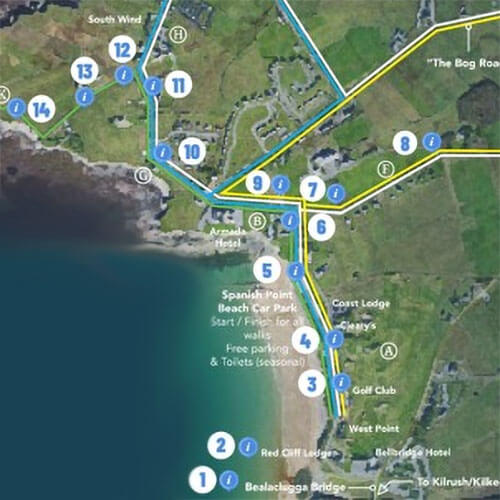
Walking Routes at Spanish Point
There are several walking routes for you to enjoy in Spanish Point. One is accompanied by an audio guide to Spanish Point, its history, and heritage. This walk follows the coast along footpaths and laneways. It starts at Bealaclugga Bridge (beside the Bellbridge Hotel) and gives a short description at fourteen points of interest as you follow the walk north to an area known as the Cross Sea or Tuama na Spáinneach. A link to the map and to the audio guide follows. You can listen to the audio guide in any order. QR codes are on display at each information point. This audio guide was funded by The Heritage Council.
There are 4 waymarked & colour coded walks that allow you to explore more of Spanish Point. These are the Kelp Walk (green route), Cleedagh Walk (blue), San Marcos Walk (yellow) and the Morony Walk (white). A short information leaflet/map (below) accompanies these walks and is available in several languages. (Note the Kelp walk follows the route of the audio guide). The information leaflet/map is also available in local hotels and guesthouses.
All walks are on footpaths, laneways or local roads. Enjoy your walk.
Waymarked Walking Routes:


Points of Interest
Welcome to Spanish Point
Spanish Point is a discovery point on the Wild Atlantic Way.
Kelp Walk 3.5km (45mins):
Walk this route to see the remains of kelp pits where seaweed was burned in the past as part of the iodine manufacturing process. Also, the location of the wrecking of “The Kelp” on the 4th of January 1916, this walk finishes at the “Graves of the Spaniards”.
Cleedagh 5km (1 hr) / Slí Leathan 3.7km (50mins):
At the northernmost point of this walk in Cleedagh Bay – paving stone bay – where stones were quarried to build roads in the area. A shorter route – Slí Leathan – or broadway – brings you through cut away bogs.
The San Marcos Walk 5km (1hr):
The San Marcos de Portugale sank off Mutton Island on 20 September 1588 and despite being a Portuguese vessel, as part of the invading Spanish Armada this event gave us our placename – Spanish Point.
Morony Walk 8km (1.5hrs):
This combination walk roughly follows the boundary of the estate of the Morony family (former landlords) and passes Miltown House built by Thomas Morony in 1780 and home to the Sisters of Mercy from 1947 to 2020. It is now in private ownership.
A
By local tradition the highest sandhill on the Golf Course (adjacent to the beach car park) is Cnoc na Crocaire or Hangman’s Hill. Survivors of the Armada shipwreck were reputedly hanged here in 1588 Follow the footpath to the Lifeguard station where the county lifeguard service started in 1936. After the monument marking the visit of the King and Queen of Spain in 1986, you will pass the “Saltwater Lodges” on the right, a row of early 19th century houses, a mixture of permanent lodges and seaside villas for rental. Turn left after the memorial garden for deceased workhouse residents.
B
Close to the Armada Hotel the ruins of the Atlantic Hotel are visible. Built in 1809, it offered tepid sea water baths and sea air to clients and was the largest hotel in the British Isles for a time. It also served as an auxiliary workhouse from 1848-1852. On the right is Sea View House, a Morony family house built in 1830 Later bought by the Mercy Order it served as a girls’ boarding school until the late 1970s.
(For the San Marcos walk turn right along L6224. Straight ahead for all other walks and go to G).
C
Follow the L6224 or “Bog Road” towards Miltown Malbay. The road is higher than the surrounding fields because the area is a cutaway bog. Turf was cut here for generations to provide fuel, when the turf was finished, the land was used to grow vegetables up to the mid twentieth century. Also in this area is Hennessy GAA Park, named after Patrick Hennessy, who was shot during the War of Independence.
D
Turn right for the footpath back to Spanish Point. Known locally as the “Railway Gates”, The West Clare Railway, built in 1891-2, crossed the road at this point and a railway gate keeper’s cottage can be seen at a characteristic angle to the road, at the junction with the N67.
E
Turn right at Goodland’s Cross and continue past Christ Church (C of I) 1927.
F
Further ahead at a bend is Wellington Cottage, home of the late Dr. Patrick Hillery, President of Ireland (1976 – 1990). Miltown House and St. Joseph’s Secondary School come next on the right.
G
(Kelp, Cleedagh, Slí Leathan and Morony Walks) If you continue straight ahead on R462 after the Armada Hotel, surfers may be seen riding the waves on the reefs off d’Esterre Strand beside “The Billows”(1810) This was the residence of William Barrington in 1900 who was chief engineer for the West Clare Railway. At Ibrickan Lodge on the left only the original gate lodge remains, shortly followed by a thatched house, Clare Cottage, once a Post Office. Settlement in this area dates back to 1780.
(Kelp Walk only: Turn left at Clare Cottage and go to K).
H
Across the road is Medina House (1840s), named after Medina Sidonia, commander of the Spanish Armada. It housed a famous donkey stud in the 1960s and 1970s, run by Lady Averil Swinfen. Admiralty Lodge was the 1850s residence of the Royal Navy Divisional Officer for Co Clare. In the grounds of the caravan park is an old National School (1870 – 1908) Spectacular views open up now – northwards to the Aran Islands and Connemara mountains, southwards to Mutton Island and its Napoleonic Telegraph signal tower (1806), Loop Head and the Kerry mountains – all are visible – on a clear day.
(Keep straight on for Cleedagh walk, turn at low stone bridge for Slí Leathan).
I
(Slí Leathan Walk) A little stone bridge marks the turn for the Slí Leathan. Built over a deep ravine as a famine relief project in 1822, the stream flows down to Pollnaceirce – the hen’s cave – a collapsed sea cave. Walk 350m through a cutaway bog, then straight ahead and follow the tarred road (8 Cleedagh Walk) back to the beach.
J
(Cleedagh Walk) Continue along “Baurtraw” – top of the strand – to overlook Cleedagh Bay. Turn sharp right at a low stone bridge onto the L6226, passing the cutaway Breaffa Bog. After 850 meters turn left and after a slight downhill turn right. Look out for an old stone outhouse with a Moher flag roof, common in the last century.
K
(Kelp Walk) Look for the remaining walls of two cottages along this lane before meeting, on the right, Armada Lodge (1775), oldest of our larger houses and, on the left, Atlantic Lodge, a Police Barracks in the Land War. In the grassy area are the parallel cuttings of the kelp pits, which are just above the rocks, where “The Kelp” was wrecked. Finally look over the wall into active farmland – the raised ground is Tuama na Spainneach —The Graves of the Spaniards. This area is also of geological and biological significance. The rocks date back over 330 million years and show wave cut platforms, ripple beds & goniatite fossils. Fragile sea fans and rare sponges as well as an excellent diversity of red and brown seaweeds make this a Special Area of Conservation.
Gaeilge:
Áiteanna Spéisiúla – Gnéithe Suimiúla – Áiteanna Suaithinseacha
A
Is é Cnoc an Chrochadóra an dumhach is airde ar an ngalfchúrsa de réir sheanchas an cheantair. Tá sé ráite gur anseo, sa bhliain 1588, a crochadh na mairnéalaigh a tháinig slán ón bhfarraige nuair a deineadh scrios ar Armáid na Spáinne.
Lean an cosán chomh fada le bothán an gharda tarrthála a bunaíodh sa bhliain 1936. Féach ar an leac, ar chlé, a tógadh i gcuimhne ar chuairt Rí agus Banríon na Spáinne i 1986.
Tá tithe saoire ón 19ú haois ar thaobh na láimhe deise, idir lóistí buana agus thithe beaga saoire atá le fáil ar cíos do cuairteoirí. ‘Lóistí an tSáile’ a thugtar orthu.Cas ar chlé tar éis dul thar an ngáirdín a tógadh I gcuimhne ar na daoine a cailleadh I dTeach na mBochta a bhíodh anseo ar feadh tamaill
Gach siúlóid: cas ar chlé.
B
Tá fothrach Óstán an Atlantaigh , a tógadh i 1809, gar d’Óstán na hArmáide.
B’ é an t-óstán ba mhó in Eirinn agus sa Bhreatain Mhór é ar feadh tamaill. B’shin an áit ina raibh aer úr na farraige le brath agus ina raibh dabhaigh bhogthe ar fáil ag cliaint . Úsáideadh é mar fhoirgneamh cúnta do Theach na mBocht ó 1848 go 1852. Ar dheis, tá Teach Radharc na Mara, teach a thóg an Tiarna Talún Ó Maolruanaidh sa bhliain 1830. Cheannaigh Ord Shiúracha na Trócaire an teach sa 20ú haois agus osclaíodh scoil chónaithe a mheall cailíní ó chian agus ó chóngar go deireadh na seachtóidí.
Siúlóid San Marcos amháin: cas ar dheis ar bhóthar L6224.
Na siúlóidí eile: lean ar aghaidh go G.
C
Téigh ar an L6224, Bóthar an Phortaigh, i dtreo Shráid na Cathrach. Tá an bóthar i bhfad níos airde ná na páirceanna mórthimpeall air toisc gur baineadh móin anseo leis na cianta. Nuair a bhí an mhóin ídithe, cuireadh glasraí de gach sórt ag fás anseo go lár an 20ú haois. Tá Páirc Mhic Aonghusa C. L. G. ag bun an bhóthair; ainmníodh í as Pádraig Ó hAonghusa, laoch áitiúil a feallmharaíodh le linn Chogadh na Saoirse.
D
Anois tá tú ar imeall an bhaile agus ní foláir duit casadh ar dheis chun filleadh ar Rinn na Spáinneach {N67}. Tugtar Geataí an Iarnróid ar an áit seo mar thrasnaigh Iarnród Iarthar an Chláir an bóthar ann ó 1891 go 1961. Tá teachín fheighlí an iarnróid le feiceáil fós ag an gcrosaire.
E
Ag Crosaire Goodlands, cas ar dheis. Téigh thar an Eaglais Phrotastúnach a tógadh i 1927 agus a fhreastalaíonn fós ar an gceantar mórthimpeall i rith an tsamhraidh.
F
Níos faide ar aghaidh, ag an gcúinne, tá Teachín Wellington le feiceáil; sin an teach ina raibh cónaí ar Phádraig Ó hIrghile, Iar–Uachtarán na hEireann (1976-1990). Tá Teach Bhaile an Mhuilinn agus Meánscoil Naomh Iósaf (thart ar 400 scoláire) le feiceáil ar thaobh na láimhe deise ina dhiaidh sin.
G
Siúlóidí Ceilpe: Cladach, Slí Leathan agus Ó Maolruanaidh
Ó Óstan an Armada téigh caol díreach ar an R462; go minic, ar chlé, bíonn daoine ag tonnmharcaíocht ar Thrá D’Esterre. Anois tá teach mór, “The Billows” (1810), le feiceáil; bhí príomhinnealltóir Iarnród Iarthar an Chláir , William Barrington, ina chónaí ann ag deireadh an 19ú haois. Ansin tá Lóiste Ibricín atá faoi chúram, Ord an FCJ. Níos faide sall feictear Teachín an Chláir (1780), teach ceann tuí ina raibh Oifig an Phoist tráth. Tá daoine ina gcónaí sa cheantar seo ó 1780.
Siúlóid Ceilpe: cas ar chlé ag Teachín an Chláir agus téir go K.
H
Trasna an bhóthair, ar thaobh na láimhe deise, tá Teach Medina (1840) le feiceáil, teach a ainmníodh as Medina Sidonia a bhí i gceannas ar Armáid na Spáinne. Bhí graí asal iomráiteach anseo ag an mBantiarna Averil Swinfen san chéad seo caite. (Is é) Lóiste na hAimiréalachta (1850) an chéad teach mór eile ar dheis. Bhíodh cónaí ar Cheannaire Áitiúil an Chabhlaigh Ríoga anseo tráth. Tá rian de sheanscoil náisiúnta (1870-1908) le feiceáil sa Pháirc Charbhán. Ón bpointe seo, nuair a bhíonn lá breá geal ann, feictear Oileáin Árann agus na Beanna Beola ó thuaidh agus feictear Túr Martello, ar Oileán Caorach, chomh maith le Ceann Léime agus Sléibhte Chiarraí, ó dheas.
Siulóid an Chladaigh (J): díreach ar aghaidh; An tSlí Leathan (I): cas ar dheis ag an droichidín.
I
Siúlóid na Slí Leithne – tógadh an droichidín cloiche seo mar thionscnamh fóirithinte le linn gorta 1822; sníonn an sruthán seo síos go dtí Poll na Circe, uaimh thitithe ar an gcósta. Lean ort ar feadh 350m trí lagphortach, ansin [téir] díreach ar aghaidh go dtí an bóthar tarráilte (agus Siúlóid an Chladaigh); cas ar dheis i dtreo na trá.
J
Lean ar aghaidh ar Bharr Trá chun féachaint amach, ar chlé, thar Bhá an Chladaigh. Cas ar dheis ag an droichead beag cloiche agus siúil ar an L6226 agus trí lagphortach; tá Portach Bhréachmhaigh ar dhá thaobh an bhóthair. Tar éis 850m, cas ar chlé, síos le fána agus cas ar dheis ag an sean-bhothán cloiche ar a bhfuil díon leaca an Mhothair, rud a bhíodh comónta sa cheantar an chéad seo caite.
K
Bítear ag faire amach d’fhothracha dhá sheanteach ar an lána seo, ansin ar chlé Lóiste na hArmáide (1775), an teach mór is ársa sa cheantar, agus, ar chlé, Lóiste an Atlantaigh, Beairic Póilíní le linn Chogadh na Talún. Thriomaítí agus dhóití an cheilp ar an bpaiste féarmhar seo tráth agus tá rian pholl na dóiteoireachta le feiscint fós. Sa bhliain 1916 chuaigh long darbh ainm ‘The Kelp’ go tóin poill amach ón gcósta . Ag bun an bhóthair, thar an mballa i dtalamh feirmeoireachta, tá Tuama na Spáinneach le feiceáil ar chnocán. Is limistéar caomhnaithe é seo – láthair thábhachtach bhitheolaíoch agus gheolaíoch.
Deutsche:
Spanish Point Spaziergänge
Willkommen in Spanish Point
Diese Broschüre dient Ihnen lediglich als information. Zeiten und distanzen sind approximativ. Auf allen kurzwanderungen werden Gehsteige und gepflasterte sowie auch Naturstrassen und wege benützt.
Fröhliche Wanderungen wünschen wir Ihnen! Spanish Point is teil der “Wilden Atlantischen Wegs”.
Kelp Walk 3.5km (45mins) Wandern Sie diese Route und entdecken Sie die Kelp-Gruben wo früher Seekraut verbrannt wurde als Teil eines Iod-Manufactur Prozesses. Dies ist auch der Ort der “Zerstörung des Kelp” (Seetang) am 4 Januar 1916. Diese Wanderung endet bei “Gräbern der Spanier”.
Cleedagh (5km/1stunde) Slí Leathan (3.7km/50min) Am nordlichsten Punkt dieser Wanderung ist Cleedagh Bay, wo früher Steinplatten für den Strassenbau in dieser Gegend gewonnen wurden. Eine kürzere Route – Slí Leathan- führt Sie über einen Weg wo früher Torf abgebaut (gestochen) wurde.
Die San Marcos Wanderung (5km/1 stunde) Das Schiff “San Marcos de Portugale” sank am 20 September 1588 in der Nähe der Insel “Mutton Island”. Obwohl ein portugiesisches Schiff, war es Teil der Spanischen Invasions Armada, der Ortname “Spanish Point” geht auf dieses Ereignis zurück.
Morony Wanderung (8km/1.5 stunde) Diese kombinierte Wanderung führt entlang den Grenzen des ehemaligen Grundbesitzes der Morony Familie (frühere Grossgrundbesitzer) und vorbei am Miltown Haus welches 1780 von Thomas Morony erbaut wurde und seit 1947 das Zuhause der Ordens Schwestern (Sisters of Mercy) ist.
A
Gemäss lokaler Ueberlieferung ist ” Cnoc na Crocaire ” (bezw. Hangman’s Hill) der höchste Sandhügel auf dem Gelände des Golfplatzes. Ueberlebende des Armada Schiffsungluck wurden angeblich im Jahr 1588 an diesem Ort erhängt. Folgen Sie nun dem Fussweg bis zur Lifeguardstation, wo der Rettungsdienst im Jahr 1936 gegründet wurde. Nach dem Denkmal welches dem Besuch des Königs und der Königin von Spanien im Jahre 1986 gewidmet ist, gehen Sie vorbei an den ” Salzwasser-Kabinen ” auf der rechten Seite, eine Reihe von Häusern des frühen 19 Jahrhunderts, eine Mixtur aus permanenten Häusern und kleinen Villas die Kurzzeitig mietbar waren. Gehen Sie in Richtung nach links nachdem Sie den Erinnerungsgarten für Verstorbene Workhouse –Insassen passiert haben.
B
Ganz nahe beim Armada Hotel sind die Ruinen des ehemaligen Atlantic Hotels erkennbar. Erbaut in 1809 offerierte es warme Meerwasserbäder und frische Meeresluft für ihre Gäste und eine Zeitlang galt es als grösste Hotel der Britischen Inseln. Es diente zeitweise auch als zusätzliches ”Workhouse” (Armenhaus) zwischen 1848 und 1852. Auf der rechten Seite befindet sich das ”Sea View House”, ein Haus der Familie Morony, erbaut im Jahr 1830. Danach wurde es vom Mercy – Orden erworben und diente bis in die späten 1970er Jahre als ”Boarding School” für Mädchen. (Für den San Marcos Wanderweg gehen Sie nach rechts und folgen der Strasse L6224, für alle anderen Wanderungen geradeaus und zum Punk G).
C
Folgen Sie der Strasse L6224 (Bog Road) die sie nach Miltown Malbay führt. Die Strasse liegt etwas erhöht vom umgebenden Gelände, wo über Generationen Torf als Heizmaterial gestochen wurde. Als aller Torf weg war wurde das Feld bis Mitte des 20. Jahrhunderts benutzt für Gemüseanbau. In der Nähe befindet sich auch der Hennessy GAA Sportplatz, benannt zu Ehren von Patrick Hennessy der während des Unabhängigkeits-krieges in Miltown Malbay erschossen wurde.
D
Am Ende des ”Bog Road” gehen Sie nach rechts. Die Strasse mit Gehsteig führt zurück nach Spanish Point. Nach kurzer Distanz überschreiten sie die ‘Railway Gates”. Hier kreuzte der ”West Clare Railway” die Strasse. Die Schmalspurbahn wurde 1891-1892 gebaut. Unmittelbar rechts steht noch, im charakteristischem Winkel zur Strasse N67, das Bahnwärter-Häuschen.
E
Bei der nächsten Strassen-Kreuzung (Goodlands Cross) gehen Sie nach rechts und folgen der Strasse, vorbei an der kleinen protestantischen Kirche (Church of Ireland) aus dem Jahr 1927.
F
Weiter vorne, bei der Strassenbiegung, befindet sich das Wellington Cottage, das Haus des Dr. Patrick Hillery, Präsident von Irland 1976 – 1990. Miltown House und St Joseph’s Sekundarschule folgen gleich darnach auf der rechten Seite.
G
(Kelp, Cleedagh, Sli Leathan und Morony Wanderungen) Wenn Sie nach dem Armada Hotel auf der Strasse R462 geradeaus weitergehen künnen Sie den Surfern zuschauen die neben dem d’Esterre Reef auf den Wellen dem Strand entgegenreiten, neben den ”Billows” (erbaut 1810). Dies war die Residenz 1900 vom William Barrington, der leitende Ingenieur für die West Clare Railway. Vom ehemaligen Ibrickan Lodge auf der linken Seite ist nur noch das Portal – Häuschen übrig geblieben und kurz darnach können sie das strohgedeckte Clare Cottage bewundern das einstmals als Postbüro diente. Diese Gegend ist seit 1780 besiedelt. (Für den Kelp Spaziergang: nach dem Clare Cottage links abbiegen und zum Punk K gehen.)
H
Auf der gegenüber der Strasse rechten Seite befindet sich das Medina – Haus (1840) benannt nach dem Kommandor der Spanischen Armada, Medina Sidonia. In den 1960er und 1970er Jahren war hier die berühmte Eselzucht, gegründet von Lady Swinfen, zu Hause. Admiralty Lodge war in den Jahren um 1850 die Residenz des leitenden Offiziers der Königlichen Flotte, zuständig für die Grafschaft Clare. Auf dem Gelände des Caravan Parks befand sich eine alte Nationale Schule (1870 – 1908). Von hier nun präsentieren sich geradezu spektakuläre Aussichten – nordwärts zu den Aran Inseln und den Bergen von Connemara, südwärts zur Mutton Insel mit dem napoleonischen Telegraph – Signalturm aus dem Jahr 1806, und weiter südlich zum Loop Head und den Bergen von Kerry die an einem Klaren Tag gut sichtbar sind. (Gehen Sie von hier weiter zum Cleedagh Walk J.)
I
(Sli Leathan Wanderung) Eine Kleine Steinbrücke markiert den Weg für Sli Leathan, gebaut über eine tiefe Schlucht im Jahr 1822 im Rahmen eines Hilfs projektes zur Linderung von Arbeitslosigkeit. Der Bach fliesst hinunter zum Pollnaceirce – Höhle der Hühner – eine zerfallene Meereshöhle. Spazieren Sie weiter ca 350 m bis zum abgebauten Torffeld, dann gleich weiter geradeaus und folgen dann dem gepflasterter Weg (und Cleedagh Walk) zurück zum Strand.
J
(Cleedagh Wanderung) Wandern Sie nun entlang ”Baurtraw” oben am Strand mit Blick über die Cleedagh Bay, von da gleich nach rechts bei einer niedrigen Steinbrücke zur Strasse L6226, entlang dem Breaffa Moor. Nach etwa 850m gehen Sie nach links und dann nach einem Kurzen Abstieg hinunter geht es nach rechts. Beachten Sie die alte Scheune die aus Stein gebaut ist und dessen Dach mit flachen Tafelsteinen (Moher flags) bedeckt ist. Diese Bauweise war früher in dieser Gegend häufig und allgemein üblich.
K
(Kelp Walk) Halten Sie Ausschau nach den nach vorhandenen Mauern von 2 einstigen cottages entlang dem weg bevor Sie rechts zum Armada Lodge gelangen. Das 1775 erbaute Gebäude ist wohl das älteste der nach vorhandenen grösseren Häuser in dieser Gegend. Auf der linken Seite befindet sich das Atlantic Lodge, die einstige Polizei Baracke während des Land Krieges. Im Wiesland nebenan befinden sich die parallelen Abschnitte der Kelp – Gruben, oberhalb der Felsen wo ”der Kelp” bearbeitet wurde. Werfen sie dann einen Blick über die Mauer auf die dortige Wiese. Der erhöhte Grund ist ”Tuama na Spáinneach” die Gräber der Spanier. Dieses Gebiet ist auch geologisch und biologisch bedeutungsvoll. Die Felsen hier sind etwa 330 Millionen Jahre alt mit gut sichtbaren Spuren von wellenförmigen Gebilden und Goniatit – Fossilien. Seltene Schwämme sowie eine Vielfalt von rotem und braunem Seekraut und viele andere seltene Meerespflanzen prädestinieren diese Gegend als Schutzgebiet.
Francais:
Points d’Intérêts

Randonnées dans Spanish Point
Spanish Point est un point de découverte sur le Wild Atlantic Way.
La Randonnée San Marcos:
Le San Marco s’est échoué au large de Mutton Island le 20 Septembre 1588. Bien qu’étant un navire portugais, il appartenait à la flotte espagnole (l’Armada) d’où le nom de l’endroit nous nous trouvons ‘’Spanish Point’’.
Chemin de Varech:
Marchez cette route pour voir les residus des fosses de varech, où anciennement des algues aient brûlées pour le processus de la fabrication de l’iode.Également ici lieu du naufrage du voilier ‘Kelp’ le 4 janvier 1916. Ce chemin termine aux ‘Tombes des Espagnols’.
Balade de Cleedagh/Slì Leathan:
Au point le plus au nord de cette randonnée se trouve Cleedagh Bay,Baie de pierres de dalle] où les pierres étaient extruites pour la construction des routes locales. Une balade plus courte –Slì Leathan- ou Broadway- Grand Sentier, vous amènera par des tourbières épuisées.
Le Tour Morony:
La combinaison de ce parcours suit quasiment la frontière de la propriété terrienne de la famille Morony (ancien propriétaire) et vous fait passer par Miltown House construite par Thomas Morony en 1780 et domicile des Bonnes Soeurs de Misèricorde depuis 1947.
A
Selon la tradition, la colline la plus haute sur le terrain de golf (parking près de la plage) s’appelle ‘’Cnoc na Crocaine’’ ou Colline du Bourreau. En effet, c’est à cet endroit que les survivants du faufrage de l’Armada ont été pendus en 1588. En suivant le trottoir, vous remarquerez le poste de secours où le service de maître nageur sauveteur a débuté en 1936. Après le monument qui commémore la visite du roi et de la reine d’Espagne en 1986, vous passerez devant les maisons des eaux salées, sur votre droite. C’est une rangée de chalets (mélange de résidences et de villas balniaires) destinés à la location. Sur votre gauche, un grand mur marque l’ancien potager de ‘’Sea View House’’
Tous les randonneurs tournent à gauche.
B
À proximité de l’hôtel Armada, vous pourrez découvrir les ruines de l’Hôtel Atlantique, construit en 1809. À cette époque, des bains d’eau de mer tièdes étaient offerts à la clientèle, ce qui explique pourquoi cet hôtel est devenu l’un des plus grands des Iles Britanniques. Il a également servi d’asile auxiliaire pour les victimes de la grande famine entre 1848 et 1852. Sur votre droite, se trouve une maison de la famille Morony, appelée Sea View House. Construite en 1830 et rachetée plus tard par les Sœurs de la Miséricorde, c’est devenu un internat de jeunes filles jusqu’à la fin de 1970s.
Tournez maintenant à droite sur la L6224 sur le chemin San Marcos.
C
Suivez la L6224, chemin de la Tourbière, vers Miltown Malbay. La route est plus élevée que les champs environnants, car c’était auparavant une tourbière, maintenant épuisée. La tourbe était coupée ici, pendant les genérations et servait de moyen de chauffage. Ensuite, les terrains ont eté utilisés pour la culture des légumes etc, jusqu’au milieu du 20ème siècle. Dans ce domaine, se trouve aussi Hennessy GAA Park (terrain de football gaélique), du nom de Patrick Hennessy tué durant la guerre d’Indépendance.
D
Tournez à droite au passage à niveau pour retourner vers Spanish Point. À cet endroit, le chemin de fer de tout le West Clare, construit dans les années 1891-1892, traversait la route. La maison du garde-barrière est encore visible à l’intersection avec la N67.
E
Tournez à droite à l’intersection Goodlands et continuez en passant par Christ Church, petite église protestante d’avant 1927.
F
Sur votre droite, se dressent Miltown House et le Lycée St Joseph.
G
Si vous continuez tout droit sur la R462, après l’Hôtel Armada, vous pourrez admirer les prouesses des surfeurs dansant sur les vagues près des récifs au large d’Esterre Strand. À côté, vous apercevrez ‘’ The Billows’’. C’était la résidence de William Barrington, ingénieur en chef du West Clare Railway (chemin de fer). À Ibriken Lodge, à gauche vous apercevrez les ruines de la maison de garde et peu après une chaumière ‘’Clare Cottage’’ qui fut un ancien bureau de poste. Dans ce quartier, les habitations datent de 1780.
Tournez à gauche pour Kelp Walk (K).
H
De l’autre côté de la route, se situe Medina House. Elle porte le nom du Commandant de l’Armada Espagnole, Medina Sedonia.Dans les années 1960-1970, cet endroit était un haras d’ânes. Admiralty Lodge (derrière Medina House) était la résidance de l’officier divisionnaire de la Marine royale pour le comté de Clare. Dans le camping, on peut encore apercevoir les restes d’une école primaire (1870 à 1908). Admirez maintenant les paysages grandioses et spectaculaires : au nord les Iles d’Aran et les montagnes du Connemara, et au sud, Mutton Island ( l’Ile des Moutons) avec sa tour de signalisation napoléonienne datant de 1806. Par beau temps et si vous êtes chanceux, vous pourriez distinguer Loop Head ainsi que les montagnes du Kerry.
Tout droit pour Cleedagh Walk (J). À droite, au petit pont de pierres pour Sli Leathan (I).
J
Continuez le long de ‘’Baurtraw’’ qui donne sur Cleedagh Bay. Tournez à droite, après 850m tournez à gauche et regardez les toits en pierres de Moher ( où l’on observe les fossils).
K
Vous remarquerez les ruines de 2 chaumières le long du chemin avant d’arriver à ‘’Armada Lodge’’, la plus vieille de nos grandes maisons, puis à gauche, Atlantic Lodge qui servait autrefois de poste de police.
Vous marchez sur une zone herbeuse où l’on brûlait le goémon pour en extraire l’iode. Regardez au-delà du mur et vous pourrez observer des monticules qui sont les tombes des naufragés espagnols.Cette zone est aussi d’une grande importance dans les cadres géologique et biologique.
Note: les épellations des noms de places viennent des cartes de 1825.
I
À droite, un petit pont de pierres vous conduit à Sli Leathan. Il a été construit en 1822, uniquement pour que les Irlandais puissent avoir un peu de travail (payés très peu par les Anglais pour leur venir en aide après la Grande Famine). Le ruisseau s’écoule vers Poll na ceirce (la grotte des poules) une grotte marine effondrée maintenant. Marchez ensuite 350 metres à travers une tourbiere, puis suivez la route goudronnée pour retouner à la plage.
Española:
Puntos de interés
Bienvenido a Spanish Point
Spanish Point es un un paraje a descubrir en el salvaje Atlántico.
Caminata Kelp 3,5km. (45 minutos):
En esta ruta podrá ver los restos de pozos de algas marinas que en antaño eran allí quemadas para la producción de yodo. También fue donde naufragó de “El Kelp” el 4 de enero de 1916. Esta ruta finaliza en las “Tumbas de los Españoles”.
Cleedagh 5km. (1 hora) / Sli Leathan 3,7km. (50 minutos):
En el punto más al norte de esta caminata se encuentra la bahía de adoquines de Cleedagh Bay, de donde se extraían las piedras para construir las carreteras en la zona. Una ruta algo más corta, Sli Leathan, o Broadway, le llevará hacia los pantanos.
Ruta de San Marcos 5km. (1 hora):
El “San Marcos de Portugale”, a pesar de ser un barco portugués, se hundió frente a Mutton Island el 20 de septiembre de 1588 formaba parte de la Armada Invencible Española. Este acontecimiento dio nombre a la zona, conocida ahora como Spanish Point.
Caminata de Morony 8km. (1 hora y 50 minutos):
Esta ruta combinada sigue aproximadamente, el límite de la propiedad de la familia Morony (unos antiguos propietarios). Pasa por Miltown House, construida por Thomas Morony en 1780 y hogar de las Hermanas de la Misericordia desde 1947.
A
Según la tradición local, el montículo de arena más alto del campo de golf (junto al aparcamiento de la playa) es Con na Crocaire o Hangman’s Hill. Se dice que los supervivientes del naufragio de la Armada fueron ahorcados aquí en 1588.
Continúe el por el sendero hasta la zona de socorrismo. Este servicio comenzó en el condado en 1936. Tras el monumento a la visita del Rey y de la Reina de España en 1986, se encuentra el “Salt Water Lodges”. A la derecha, se halla una fila de casas de principios del siglo XIX, una mezcla de alojamientos y villas junto al mar disponibles para alquilar. Gire a la izquierda después de pasar el jardín conmemorativo a los residentes fallecidos del asilo.
B
Cerca del Armada Hotel se pueden observar las ruinas del Atlantic Hotel. Construido en 1809, ofrecía baños de agua de mar tibia y aire marino a sus clientes. Fue el hotel más grande de las Islas Británicas durante un tiempo. También sirvió como casa auxiliar de trabajo desde 1848 hasta 1852. A la derecha, aparece la Sea View House, una casa de la familia Morony construida en 1830. Más tarde fue comprada por Mercy Order, que la convirtió en internado para niñas hasta finales de la década de 1970.
(Para el paseo de San Marcos, gire a la derecha a lo largo de L6224. Siga recto para todos los demás paseos y vaya a la G).
C
Siga la L6224 o “Bog Road” hacia Miltown Malbay. El camino está más alto que los campos que rodean la zona, porque el área es un pantano. El césped se cortó durante generaciones para proporcionar combustible. Cuando éste se agotó, la tierra se utilizó para cultivar hortalizas hasta mediados del siglo XX.
En esta zona se encuentra el Parque Hennessy en honor de Patrick Hennessy, quien recibió un disparo durante la Guerra de la Independencia.
D
Gire a la derecha por el sendero de regreso a Spanish Point. Este sendero es conocido localmente como “Railway Gates”, The West Clare Railway, fue construido entre 1891 y 1892.
Si cruza la carretera en este punto, en un ángulo característico de la carretera, se puede ver la cabaña de un guardabarreras, en el cruce con la N67.
E
Gire a la derecha en Goodlands Cross y deje atrás Christ Church (C of l) 1927.
F
Más adelante, en una curva, se encuentra Wellington Cottage, hogar del difunto Dr. Patrick Hillery, presidente de Irlanda (1976 – 1990). A continuación, se encuentran Miltown House y St. Joseph’s Secondary School.
G
(Kelp, Cleedagh, Sli Leathan y Morony Walks) Si continúa recto por la R482, después del Armada Hotel se pueden contemplar surfistas cogiendo las olas en los arrecifes de d’Esterre Strand junto a “The Billows” (1810). Esta fue la residencia de William Barrington, ingeniero jefe de West Clare Railway en 1900. En Ibrickan Lodge, a la izquierda, solo queda la puerta de entrada original, seguida poco después por una casa con techo de paja, Clare Cottage, que alguna vez fue una oficina de correos. El asentamiento humano en esta área se remonta a 1780.
(Solo Kelp Walk: gire a la izquierda en Clare Cottage y vaya a K)
H
Al otro lado de la calle está Medina House (década de 1840), llamada así por el Duque de Medina Sidonia, comandante de la Armada Invencible. El lugar albergó un famoso semental de burros de las décadas de 1960 y 1970, dirigida por Lady Averil Swinfen. Admiralty Lodge fue en la década de 1850…
I
(Paseo de Slí Leathan) Un pequeño puente de piedra marca el desvío hacia el Sí Leathan. Construido sobre un barranco profundo como un proyecto de alivio de la hambruna en 1822, el arroyo fluye hacia Pollnaceirce, la Cueva de las gallinas, una cueva marina derrumbada. Camine 350m. a través de un pantano cortado, luego siga recto y continúe por la carretera asfaltada (y Cleedagh Walk) de regreso a la playa.
J
(Paseo de Cleedagh) Continúe por “Baurtraw”, la parte superior de la playa, para pasar por la bahía de Cleedagh. Gire bruscamente a la derecha en un puente de piedra bajo, hacia la L6226, pasando Breaffa Bog. Después de 850m. gire a la izquierda y tras una ligera bajada hacia la derecha, busque una antigua letrina de piedra con un tejado con la bandera de Moher, común en el siglo pasado.
K
K) (Kelp Walk) Busque las paredes restantes de dos cabañas a lo largo de este sendero antes de encontrar a la derecha la Armada Lodge, un cuartel de policía en la guerra terrestre. En el área cubierta de hierba se encuentran los cortes paralelos de los pozos de algas marinas, situadas encima de las rocas, donde naufragó “The Kelp”. Finalmente contemple por encima del muro las tierras de cultivo actualmente activas. El terreno elevado es Tuama na Spáinneach, las “Tumbas de los españoles”. Esta área tiene importancia geológica y biológica. Las rocas datan de hace más de 330 millones de años y muestran plataformas con cortes creados por las mismas olas, lechos ondulados y fósiles de goniatita. Frágiles gorgonias e inusuales esponjas, así como una excelente diversidad de algas rojas y pardas, hacen de ésta una zona de especial conservación.